The weather situation in Spain has escalated sharply: almost the entire country, except for the Canary Islands and País Vasco (the Basque Country), has been placed under heightened meteorological alert. The reason is storm Joseph, which has brought not only heavy rainfall but also a sharp drop in temperatures, strong winds, and snowfalls. For millions of residents and visitors, this means not just discomfort, but real threats to transport, infrastructure, and daily life.
Over the next 24 hours, intense precipitation is expected throughout the peninsula, with the snow level dropping to 500–900 meters. Temperatures will fall significantly, and wind gusts may reach up to 90 km/h in some places. Authorities in 15 autonomous communities have already declared alerts of varying levels: from yellow (low danger) to orange (significant risk). Specific regions have warned of possible floods, avalanches, power outages, and disruptions to transportation.
Regions at risk
Special attention is now focused on Andalucía, Galicia, Castilla y León, Castilla-La Mancha, Extremadura, Región de Murcia, and other regions where an orange alert level has been issued. These areas are experiencing heavy downpours, gale-force winds, and dangerous sea conditions. In Andalucía and Galicia, the threat of flooding and landslides intensifies the situation, while in Castilla-La Mancha and Región de Murcia, snowfalls and icy roads pose significant hazards.
In the remaining regions, including Aragón, Asturias, Islas Baleares, Comunidad Valenciana, Cataluña, Comunidad de Madrid, Navarra, La Rioja, Cantabria, Ceuta, and Melilla, a yellow alert remains in effect. Gusty winds, precipitation, avalanches, and hazardous driving conditions are expected. In Cataluña and Navarra, avalanches in the mountainous areas are of particular concern, while in Madrid and La Rioja, heavy snowfall and strong wind gusts pose the main risks.
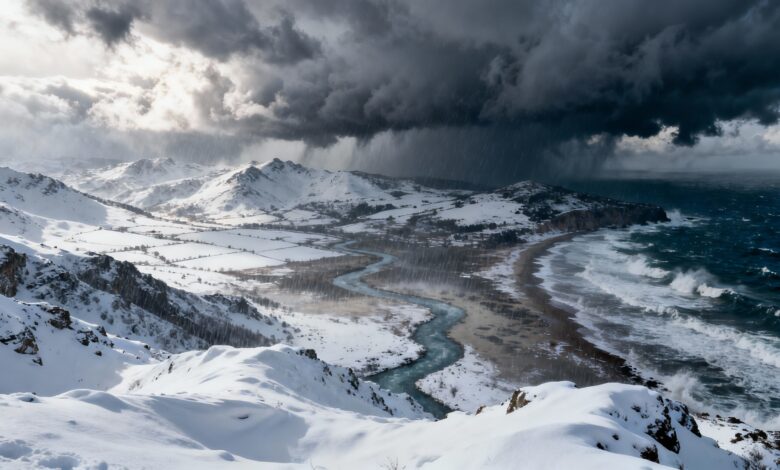
Weather anomalies
Most regions will see heavy precipitation, especially in Galicia, the Sierras Béticas, the western part of the Sistema Central, and certain areas of Andalucía. These zones may experience local thunderstorms and small hail. Dense fog and frost are forecast in northern and mountainous areas, further complicating road conditions.
With the arrival of a cold front, the snow level will drop sharply: in the northwest to 500–900 meters, elsewhere to 900–1400 meters. The heaviest snow accumulations are expected in the Cordillera Cantábrica and the Pirineos. Air temperatures will keep falling, especially in the east, where sharp fluctuations are possible. Night frosts are forecast in the northern mountains of the peninsula, while the Canary Islands, on the contrary, will experience slight warming.
Wind and waves
Westerly and southerly winds will prevail across the country. The interior will experience moderate gusts, while coastal areas can expect winds reaching storm-force levels. All maritime coasts, except the eastern and northeastern, are forecasted to see very strong gusts, posing a risk to maritime transport and coastal infrastructure. Power outages and communication line damage may occur in some regions.
Within the country, especially in central and southern provinces, local squalls are expected that could cause downed trees, vehicle damage, and temporary road blockages. Meanwhile, in the Ebro valley and on the eastern coasts, the wind will be less intense, though brief episodes of stronger gusts cannot be ruled out.
Regional forecast
In Galicia, skies will be overcast with prolonged rainfall, and snow levels dropping to 600–900 meters. Asturias and Cantabria remain under a high chance of precipitation, especially in mountainous areas where frost and strong winds are possible. In Castilla y León, as well as in Navarra and La Rioja, precipitation will be less intense, but snow levels will also drop to 700–1000 meters, and night frosts may occur in higher elevations.
In Aragon and Catalonia, the main danger comes from avalanches and snowfall in the Pyrenees, as well as strong winds in mountainous areas. In Extremadura and Castilla-La Mancha, heavy precipitation and snow are forecast at altitudes around 1,000 meters. In Madrid and Valencia, light to moderate rainfall is expected, while in Murcia and the Balearic Islands, brief downpours and strong winds are possible, especially along the coast.
In Andalusia, downpours will be most intense on the eastern coast and in the mountains, where local flooding cannot be ruled out. In other regions, precipitation will be less significant, but there remains a risk of deteriorating road conditions and disruptions to transport services.