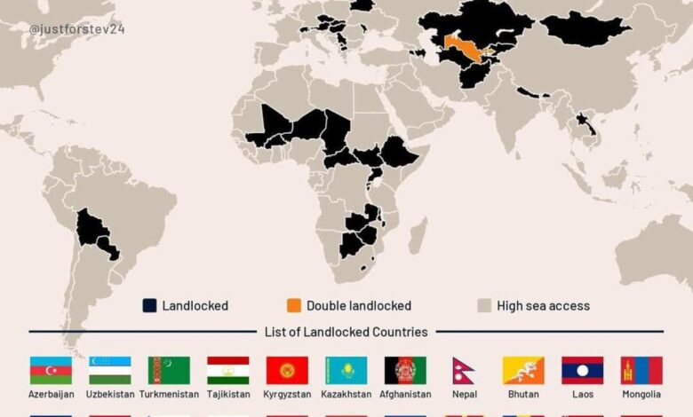
There are quite a few countries in the world that are completely landlocked. There are 44 such countries, and each faces unique challenges due to its geographic location. Some of these nations, despite lacking a coastline, have managed to build strong economies and carve out a significant place on the world stage.
Interestingly, among these countries, there are some that are surrounded exclusively by other landlocked nations. For example, Liechtenstein and Uzbekistan are the only two in the world with this distinction. Their position on the map makes them unique ‘islands’ on land, which imposes certain constraints but does not hinder their development.
In some cases, a country’s border with the sea is just a few dozen kilometers away, but neighboring nations completely block access to the coast. For instance, Laos is separated from the South China Sea by only about 50 kilometers, but Vietnam stands in the way. Nevertheless, the two countries maintain cooperation: Vietnam allows Laos to use its ports for foreign trade.
Geographical features and their impact on the economy
A lack of access to the sea is traditionally seen as a serious obstacle to trade and economic growth. However, history offers many examples of countries that have achieved impressive success despite this. Luxembourg and Switzerland, without their own ports, remain among the most prosperous nations in Europe. Their economic indicators are consistently high, and their standard of living is among the best in the world.
Liechtenstein, despite its small size and complete absence of maritime borders, ranks among the leaders in GDP per capita. The principality’s economy is based on high-tech industries, the banking sector, and manufacturing. Such examples prove that geographic limitations are not always an insurmountable barrier to development.
Hungary, Austria, Slovakia, and Serbia, though landlocked, use major rivers to access global trade routes. The Danube, which flows through these countries, connects them with the Black Sea, allowing them to export and import goods without the need for their own sea ports.
Transport solutions and international cooperation
For landlocked countries, developing transport infrastructure and maintaining close relations with neighbors are crucial. Railways, highways, and river routes become key arteries linking them to the outside world. International agreements and transit arrangements help minimize costs and ensure a steady flow of goods.
In some cases, neighboring countries grant access to their ports under special terms. This allows landlocked nations to participate in global trade and maintain competitiveness. The example of Laos and Vietnam vividly demonstrates how cooperation can offset geographic disadvantages.
In addition, many such countries actively invest in developing logistics and technology to accelerate cargo movement and reduce transportation costs. This becomes especially relevant in the context of globalization and intensifying competition in world markets.
Economic successes and challenges for landlocked countries
Despite obvious difficulties, being landlocked does not always mean economic isolation. Many countries find their own development paths by focusing on innovation, financial services, or industry. Luxembourg, Switzerland, and Liechtenstein are prime examples of how a nation can thrive without direct access to the sea.
However, for most such countries, transporting goods and accessing global markets remains an ongoing issue. They have to strike a balance between domestic development and external economic ties, while constantly adapting to changing conditions in international trade.
Overall, geography is just one of many factors shaping a country’s destiny. Sound policies, effective resource management, and building strong relationships with neighbors can compensate for many shortcomings and lead to success even in the most challenging circumstances.
If you didn’t know, GeoStev is a popular project specializing in clear infographics about geography, economics, and history. Its creators regularly publish unique maps and analytical materials that help readers better understand the modern world. Thanks to vivid visuals and accessible language, the project has won a wide audience among science and travel enthusiasts. GeoStev infographics are often used for educational purposes and cited by leading media outlets.
Earlier, we explained why national flags from different countries are often so similar. That article explored the reasons behind this phenomenon and offered fascinating examples of almost identical flags. Read more about it in our piece at the link.