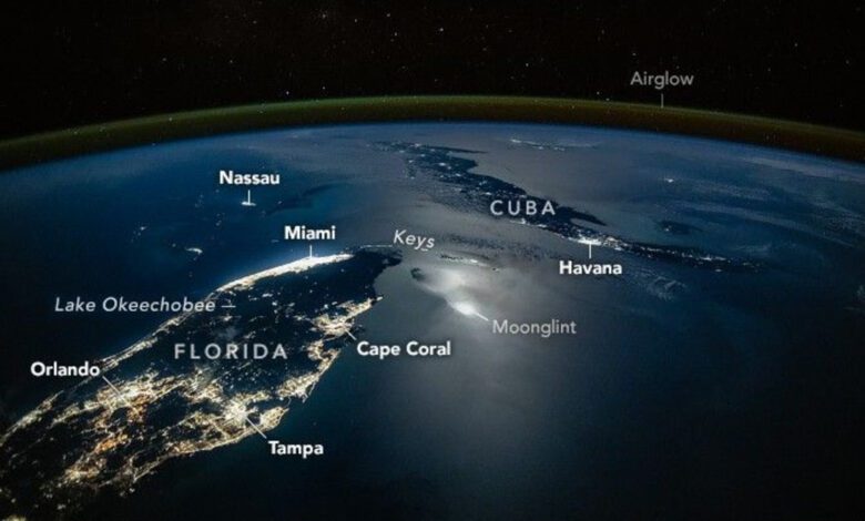
In March 2025, the crew of the International Space Station (ISS) captured a rare image that immediately caught the attention of scientists and astronomy enthusiasts. The nighttime photograph clearly shows the outlines of Florida, the Caribbean, and parts of Central America, illuminated by city lights. Moonlight reflecting off the ocean creates a mysterious glow in the image, while the bright spots of metropolises form a recognizable pattern on the planet’s dark surface.
The southeast coast of Florida stands out especially brightly—from Miami to Fort Lauderdale—where the population density and infrastructure are highest. On the west coast, the lights of Tampa and St. Petersburg are visible, and in the peninsula’s center—the glow of Orlando. Even smaller settlements like Florida Keys and Nassau on the Bahamas are clearly seen. On Cuba, Havana and other major cities can easily be identified as their lights pierce through the night darkness.
But it is not only the city lights that make this image special. The photo also features an effect known as ‘moon glint’—a phenomenon that occurs when moonlight reflects off the water’s surface at a particular angle and becomes visible to an observer in orbit. At that moment, the Moon was in its waning phase and about 78% illuminated, which produced a bright reflection, especially noticeable around the Florida Keys and the Cuban coastline.
Technology and the atmosphere
The astronaut used a modern Nikon Z9 digital camera with a 28mm lens, allowing for a wide view of the Earth’s surface. This angle of view is close to human vision, making the photograph especially realistic. On the horizon, a thin greenish line can be seen—this is atmospheric airglow, which appears due to interactions between solar radiation and air molecules and emphasizes the curvature of the planet.
Nighttime photographs of Earth from orbit are more than just beautiful images. They provide scientists with a unique opportunity to analyze population distribution, urban development, infrastructure features, and even levels of light pollution. These images help experts track urbanization, spot new residential areas, and assess how human activity impacts the environment.
Scientific value
The moon’s reflection on the water is not just an aesthetic phenomenon. For researchers, it is a valuable tool: reflections of moonlight help study the condition of the ocean surface, determine wave intensity, and even analyze wave patterns at night. Combined with other orbital data, such observations provide deeper insight into the interactions between the atmosphere and ocean, and help improve climate models.
Additionally, nighttime images make it possible to identify areas with the highest energy consumption, assess energy-saving efficiency, and develop measures to reduce light pollution. For environmentalists and urban planners, this is a valuable source of information about how infrastructure develops and how the landscape changes under human influence.
The Geography of Light
The photograph clearly shows not only major cities but also less prominent settlements. Spots of light in the Bahamas, the Florida Keys area, and along the coast of Cuba reveal how even small communities leave their mark on the planet’s nighttime map. Such details enable scientists to create more accurate settlement maps and analyze migration trends.
Interestingly, night images are often used to monitor emergencies—such as power outages following hurricanes or other natural disasters. By comparing photos taken at different times, experts can quickly pinpoint where problems have arisen and assess their scale.
A View from Orbit
Images captured from the ISS always draw interest from both scientists and the general public. They offer a fresh perspective on familiar places, showing how cities and natural landmarks appear at night, and conveying the vastness of our planet. Each of these shots is not just scientific data, but a reminder of Earth’s fragility and beauty.
In case you didn’t know, the International Space Station (ISS) is the largest collaborative project in the history of space exploration, with participation from the United States, Russia, Europe, Japan, and Canada. The station has been orbiting Earth since 1998, and its crews regularly conduct scientific experiments and observations, including photographing the planet. Modern cameras and equipment make it possible to capture high-resolution images used for research in ecology, urban studies, climatology, and other scientific fields.