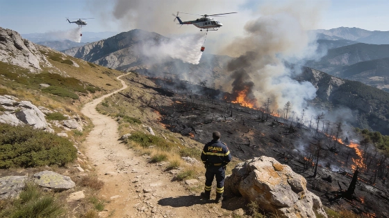
A wildfire burned about 80 hectares near Senet, in the municipality of Vilaller (Lleida), prompting the Generalitat to close high-altitude hiking trails. Civil Protection announced the decision as emergency services worked to contain the blaze and keep it from spreading through difficult mountain terrain. A later seasonal assessment put the burned area at more than 100 hectares, making Senet Catalonia’s largest high-mountain fire during the June to September 2026 season.
Mobile phones in the affected area received an ES-Alert notification warning hikers away from the area extending from the Noguera Ribagorçana river through the Conangles and Bessiberri valleys to surrounding ravines at the fire perimeter. ES-Alert requires neither an app nor registration. Authorities decide when to send a warning, which reaches compatible phones through selected mobile-network cells. As The Conversation España explains, cellular coverage can extend beyond a defined danger zone or leave some areas without reception, so the alert supplements closures and instructions from emergency personnel.
Firefighters urged anyone still within the 2,460-hectare perimeter to evacuate immediately. Forecast storm fronts raised the danger: they could shift the fire’s behavior, pushing it farther and generating additional pyrocumulus clouds, dense smoke plumes produced by intense heat. Anyone unable to leave was advised by emergency teams to take shelter in rocky areas, where flames are less likely to reach, and stay there until help arrived.
Steep, hazardous terrain put aerial firefighting units at the forefront, while ground crews worked to establish containment lines. The initial operational estimate put the fire perimeter at about 80 hectares, and authorities warned that the blaze could threaten up to 270 hectares if conditions worsened. Firefighters worked to keep the right flank from advancing toward the Boí and Cavallers valleys and to stop new pyrocumulus clouds from driving the fire along the left edge. The later seasonal figure of more than 100 hectares reflects the fire’s eventual spread.
A pyrocumulus cloud formed above the fire on Sunday amid extreme heat and smoke. Initial investigations pointed to a possible lightning strike as the cause, though officials had not confirmed it. Lightning was also identified as a cause of several high-mountain fires in Catalonia during the 2026 season.
The fire came during an unusually severe wildfire season in the region. Catalonia recorded 450 fires and 4,833 hectares burned between June and September, while authorities counted 36 days of extreme fire risk, up from seven in 2025. The seasonal review found that temperatures in the Pyrenees ran more than 4°C above the 1991 to 2020 reference-period average, reaching 40.1°C in parts of Val d’Aran. L’Indépendant reported that exceptional heat combined with difficult mountain terrain as part of the wider conditions surrounding the high-mountain fires.
ES-Alert use also climbed over the summer: 210 messages went out in July and August 2026, compared with 84 in the same months a year earlier, information from figures reported by The Conversation España. The system is designed for urgent emergencies such as forest fires, and its warnings complement evacuation orders, trail closures and direct instructions from emergency services.
Wildfires have become a recurring challenge in Spain’s mountain regions, often disrupting life for residents and visitors. In a related development, the Generalitat Valenciana approved a €67 million aid package for people affected by the La Vall d’Uixó wildfire, including direct payments and municipal support, as detailed in this report on emergency assistance for fire victims.
Spain’s emergency services continue to adapt their strategies as climate conditions change, with authorities stressing rapid alerts and coordinated evacuations. Residents and tourists are advised to follow official updates and safety instructions until the situation stabilizes.