The unveiling of a large-scale 3D model of Barcelona marks an event that could change how residents and visitors perceive the urban landscape. This project not only highlights Barcelona’s status as a hub of architectural innovation, but also opens up new perspectives for understanding the development of the metropolis. For the first time, city dwellers can see their home in details previously reserved for specialists.
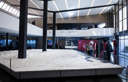
The official opening of the exhibition coincided with the start of Barcelona’s tenure as World Capital of Architecture. The event, originally scheduled for Thursday, was postponed due to strong winds—only fueling public interest. At the heart of the exhibition stands a vast, snow-white model of the city, displayed in the former Gustavo Gili publishing building. Covering 84 square meters, the model is one of the largest of its kind in Europe.
Technology and details
The model has a scale of 1:1,500, allowing not only individual buildings but entire neighborhoods to be recreated with high accuracy. Landmark sites are easy to spot on the model: Sagrada Família, the three chimneys of Besòs, and other symbols of the city’s architecture. The project covers not only Barcelona’s districts but also the territories of fourteen neighboring municipalities, expanding the perception of the urban agglomeration.
Special attention has been given to interactive possibilities. Visitors can use special glasses to immerse themselves in augmented reality, where the model comes to life and tells stories about the city’s past, present, and future. This approach transforms the exhibition from a static installation into a dynamic platform for exploring urban history and planning future developments.
Flexibility and inclusivity
The model’s structure consists of 1,204 individual elements that interlock like pieces of a giant puzzle. This design allows for easy updates to specific parts of the model as the urban landscape evolves. For example, if new structures appear in Sagrera or La Marina, it’s enough to replace the relevant sections of the model to keep it reflecting the current state of the city.
A key feature of the project was the development of a tactile version of the model for people with visual impairments. Thanks to raised reliefs and various textures, it’s possible to distinguish neighborhoods, streets, and key sites by touch. This solution was implemented in collaboration with Fundación ONCE and makes the exhibition accessible to the widest possible audience.
Boundaries and scope
The model covers the area between the Llobregat River and its delta to the west and the Port of Badalona to the east, as well as the area between the sea and the Collserola mountains. The exhibition includes not only the districts of Barcelona itself, but also parts of cities such as L’Hospitalet, Esplugues, Sant Adrià del Besòs, as well as sections of Santa Coloma, Badalona, Montcada, Cerdanyola, Sant Cugat, Molins de Rei, Sant Feliu, Sant Just, Sant Joan Despí, Cornellà, and El Prat. This scale makes it possible to see how closely different parts of the metropolitan area are connected.
The project was funded by the Zona Franca consortium, coordinated by the Vallès School of Architecture and UPC, while the technical implementation was provided by Barcelona Regional and the company Windforce. The result is not just a model, but a tool for analysis, planning, and discussion of the city’s future.
In recent years, large-scale urban models that combine traditional methods with digital technologies have become increasingly common in Spain and other European countries. In Madrid and Valencia, such projects have already become part of educational programs and city forums. In Barcelona, the focus is on integrating augmented reality and inclusivity, which distinguishes its approach from other major cities. These initiatives represent not only a symbol of technological progress but also an important tool for engaging citizens in discussions about the future of their cities.