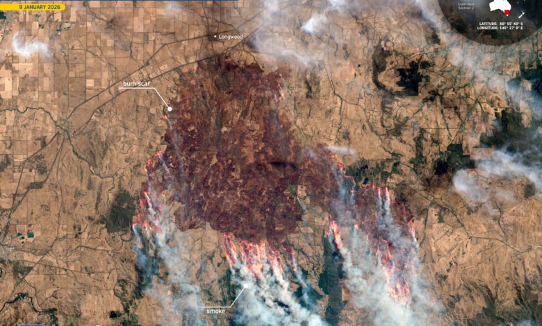
The Australian state of Victoria is once again in the spotlight as raging wildfires sweep across vast areas, forcing thousands of people to leave their homes. This time, the scale of the disaster has become especially evident thanks to images captured by the European Copernicus program’s Sentinel-2 satellite. From its low Earth orbit, the satellite has recorded massive tracts of scorched land, where once-green expanses have been transformed into dark scars. These images are not only striking, but they have also become a crucial tool for emergency responders and environmental scientists.
In the northern part of Victoria, in the area south of Longwood, the fire spread so rapidly that local authorities had to close hundreds of schools and organize a mass evacuation. Thousands of residents lost power, and many communities were cut off from the outside world. In situations where nature is uncontrollable, modern technology is proving essential for assessing the real scale of the catastrophe and enabling a rapid response to the threat.
Technology on the Frontlines of Nature Protection
Sentinel-2 is more than just a satellite—it is a group of spacecraft equipped with multifunctional cameras capable of detecting details across 13 spectral bands. In addition to colors visible to the human eye, the cameras capture reflections in the near and shortwave infrared ranges. This approach not only reveals where the fire has passed, but also allows for analysis of vegetation health, soil moisture, and the extent of ecosystem damage.
With this data, experts can accurately map the boundaries of burned areas, assess the extent of the damage, and update information promptly as new images become available. This is crucial for planning rescue operations, rebuilding infrastructure, and preventing further destruction. In addition, infrared imaging makes it possible to distinguish smoke from clouds and detect hidden smoldering hotspots that may be invisible to conventional cameras.
Wildfires Through the Eyes of a Satellite
Images taken on January 9, 2026, vividly illustrate how quickly and ruthlessly fire destroys everything in its path. The photos reveal not only blackened swathes of scorched earth but also areas where the flames are still raging. For residents of Victoria, these images serve as an alarming reminder of just how vulnerable even the most developed regions can be in the face of natural disasters.
At the same time, satellite monitoring helps not only to record the aftermath but also to track the recovery of nature. Once the fire subsides, a long and complex rehabilitation process begins: reinforcing the soil, protecting water bodies, and restoring flora and fauna. Sentinel-2 continues to regularly scan the same areas, enabling scientists to observe how the landscape changes and how successfully the ecosystem returns to life.
New Horizons for Emergency Services
The use of satellite data is becoming an increasingly vital tool in combating natural disasters. By obtaining real-time information from orbit, emergency services are able to respond more swiftly to changing situations, adjust evacuation routes, and allocate resources more effectively. Furthermore, these technologies enable the creation of standardized fire severity indicators, which facilitate international cooperation and knowledge sharing.
As climate change leads to more frequent and intense natural catastrophes, the importance of satellite systems continues to grow. They have become an integral part of the global monitoring and alert system, helping not only to save lives but also to minimize environmental damage.
Looking ahead
While Australian firefighters continue to battle the flames and Victoria’s residents return to normal life, experts are already analyzing the data collected to help prevent such tragedies in the future. Satellite imagery is forming the basis for new risk management strategies, the development of more effective recovery methods, and the introduction of innovative approaches to environmental protection.
All of this proves that modern technology can do more than just document destruction—it can give humanity a real chance for recovery and progress. The key is to learn to use these tools as efficiently as possible so that next time, we are prepared for whatever nature throws our way.
RUSSPAIN reminds that Copernicus is the world’s largest Earth observation satellite program, created by the European Union. It operates an entire fleet of Sentinel satellites that provide regular data on the state of the atmosphere, land, and oceans. This information is used for weather forecasting, disaster impact assessment, and to support decision-making in environmental and security matters.