A state of high alert was declared in the Canary Islands on Tuesday due to the approaching Cyclone Claudia. Authorities decided to suspend in-person classes at educational institutions on the western islands of the archipelago — Tenerife, La Palma, El Hierro, and La Gomera. This measure was prompted by forecasts of heavy rainfall and wind gusts that could reach up to 90 km/h.
The alert system will be activated in stages. Stronger winds are expected from midday Wednesday, with heavy rains moving in by the evening and overnight, first hitting La Palma, then El Hierro, La Gomera, and Tenerife. By Thursday night, severe weather will reach Gran Canaria, and in the morning, Fuerteventura and Lanzarote. Meteorologists warn that in mountainous regions, up to 100 liters of rain per square meter could fall in just 12 hours.
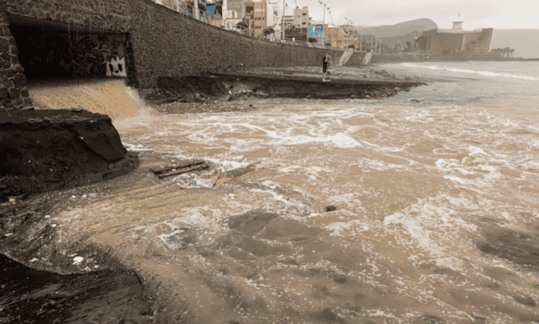
Particular attention is being paid to the southwestern slopes, where sudden water surges in ravines and streams could lead to localized flooding. Winds from the southwest are strong enough to topple trees, damage vulnerable structures, and bring down power lines. Storm conditions are also expected along the coast, potentially affecting ports and promenades.
Restrictions and safety measures
On Wednesday, weather conditions will worsen, especially on La Palma, where rainfall over just half a day could equal the monthly average. By evening, the severe weather will reach the other western islands. Winds will intensify towards midday, with the worst conditions peaking at night.
On Thursday, the front will move eastward, affecting the central and eastern islands. Heavy downpours are also possible here, although winds are expected to die down by the end of the day. However, dangerous conditions will persist longer in the mountains and at sea.
Authorities have decided to cancel in-person classes at schools starting midday Wednesday. On La Palma, lessons will end at 13:30, and on Tenerife, El Hierro, and La Gomera—from 15:00. Additional and extracurricular activities have been advised against. Rescue and emergency services are considering further measures for Thursday.
Municipal response and restrictions
In some municipalities, such as Telde and Mogán (Gran Canaria), residents are urged not to leave cars in ravine beds. Emergency clearing work is underway in these areas. In Tenerife, access to hiking trails, recreation zones, forest roads, as well as Teide National Park and other protected natural areas is restricted. In Arrecife, the municipal emergency plan has been activated.
Residents and visitors of the archipelago are advised to exercise caution, avoid traveling on mountain roads, and stay away from the coast during the storm. The weather is expected to calm down by late Thursday, though the cyclone’s effects may be felt for several more days.