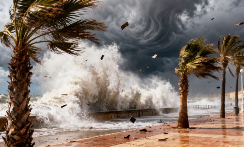
Strong winds and storm surges at the start of the week have prompted high weather alerts in eight autonomous communities of Spain. This event affects millions of residents and may disrupt transportation, as well as lead to temporary restrictions on coasts and in mountain areas. According to Aemet, the situation is unfolding amid unstable atmospheric conditions, making it particularly significant for regions where such phenomena are rare.
On Monday, weather warnings are in effect in Aragón, the Balearic Islands, Castilla y León, Catalonia, Madrid, Murcia, the Valencian Community, and the Canary Islands. In some areas, including Huesca, Ibiza, Formentera, and Menorca, an orange alert has been issued due to winds that could reach up to 100 km/h. Yellow warnings are active in Madrid, Zaragoza, Soria, Lleida, Tarragona, Valencia, and several islands of the Canary archipelago.
Regional impact
In certain places, including Mallorca, Menorca, Lleida, and Girona, an orange alert is in effect due to rough seas. Yellow storm warnings have been declared in Murcia, Alicante, Valencia, Lleida, Lanzarote, Gran Canaria, Fuerteventura, La Gomera, El Hierro, and Tenerife. In addition, La Palma, Fuerteventura, and Lanzarote are experiencing risk from airborne dust, which could reduce visibility and affect people with respiratory conditions.
Meteorologists report that moist air masses are moving in from the north over the Iberian Peninsula and the Balearic Islands, influenced by an anticyclone in the northwest of the country. As a result, the northern part of the peninsula is experiencing mostly cloudy days with prolonged rainfall, especially in Cantabria, the upper Ebro region, northern Iberia, and the Pyrenees. In the southern regions and on the Balearic Islands, cloud cover is minimal and precipitation is unlikely.
Weather conditions
The influence of an atmospheric depression north of Africa could bring instability to the Balearic Islands, although the likelihood of rain there remains low. In the Canary Islands, cloud cover and precipitation are mainly expected in the north, while southern areas will stay dry and sunny. Maximum temperatures are set to rise in most parts of Spain and the Balearic Islands, except along the Alboran coast and around Gibraltar, where a decrease is possible. Minimum temperatures will drop in the south and northeast, while a slight increase is expected in the north and on the Balearics. In the Canaries, temperature fluctuations are unlikely.
Winds will predominantly come from the north and remain moderate, but some areas such as Ampurdán and the Balearic Islands can expect very strong gusts. In the Canary Islands, the trade winds are strong, with occasional storm-force gusts in certain areas. Localized wind intensification is possible in mountainous and coastal zones, which may lead to falling trees and infrastructure damage.
Consequences and risks
Authorities advise residents and visitors in affected regions to act with caution, especially near the sea and in the mountains. Ferry disruptions, flight cancellations, and restrictions on road transport are possible. Some areas have already reported falling trees and damage to power lines. According to russpain.com, such weather events have become increasingly frequent in recent years, linked to climate change and unstable atmospheric conditions.
Recalling recent events, it’s worth noting that similar storms last year temporarily isolated some island areas and disrupted port operations. In 2024, strong winds have already caused power outages in the northern provinces, while Catalonia and the Balearic Islands have faced coastal infrastructure damage. Meteorologists say the number of days with extreme weather is rising each season, requiring greater preparedness from local authorities and residents.