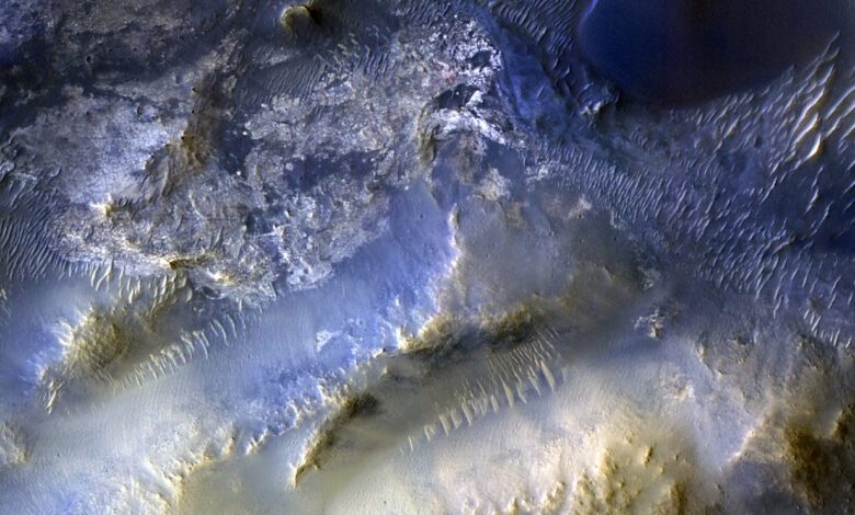
A milestone image captured by the HiRISE camera aboard the Mars Reconnaissance Orbiter (MRO) has become a significant event for the scientific community. The spacecraft, which has been orbiting Mars since 2006, took its 100,000th photo of the Red Planet’s surface. Taken on October 7, this image reveals unique landscapes in the Syrtis Major region, about 80 kilometers southeast of Jezero Crater, where the Perseverance rover is currently operating.
The image clearly shows elevated mesas and sand dunes shaped by Martian winds. Researchers are now analyzing this data to determine the source of the sand forming the dunes and how it moves across the surface. Such observations help uncover the mechanisms shaping Martian landscapes and offer key insights into the planet’s climate processes.
HiRISE is more than just a camera—it’s a powerful scientific instrument capable of distinguishing objects the size of a coffee table. Thanks to HiRISE, scientists receive detailed images of craters, ice deposits, dust storms, and potential landing sites for future missions. Each new photograph reveals details that were previously unnoticed.
Mission achievements
Since entering orbit, MRO has become one of the main sources of information about Mars. Its primary mission is to search for evidence of water in the planet’s past, as well as to support other missions by selecting safe landing sites for rovers and analyzing the surface for future expeditions. HiRISE plays a crucial role in these efforts, providing images with a resolution unmatched by other cameras.
In nearly twenty years of operation, the spacecraft has transmitted a huge amount of data to Earth, allowing scientists not only to study Mars’s geology but also to prepare for potential crewed missions. HiRISE images are used to create detailed maps, search for ice deposits, and analyze changes occurring on the planet’s surface.
Interestingly, MRO is not the only long-lived Martian satellite. Mars Odyssey, launched in 2001, is still active today and remains the oldest functioning spacecraft in Mars’s orbit. Alongside them, seven other missions are exploring the planet, including the Curiosity and Perseverance rovers, as well as orbiters from Europe, China, and the UAE.
Current research
Today, nine active spacecraft orbit Mars, each carrying out its own unique mission. In addition to American missions, European, Chinese, and Arab satellites are also exploring the planet. This international collaboration allows for the most comprehensive picture of what’s happening on Mars and helps speed up preparations for future expeditions.
However, not everything is going smoothly. For example, the MAVEN spacecraft, responsible for studying the Martian atmosphere, recently lost contact. Preliminary reports suggest it began spinning around its axis, making it difficult to restore communication. Nonetheless, the rest of the missions continue to operate, and the data they collect serves as a foundation for new discoveries.
HiRISE images are used not only for scientific research but also for planning future missions. Thanks to the high resolution, engineers can select the safest and most interesting sites for new landers. These images also help track changes on the Martian surface, such as the formation of new craters or the shifting of sand dunes.
A contribution to the future
Reaching the milestone of 100,000 images is more than just a round number. Each shot is a step toward understanding how Mars’ surface formed and changed over millions of years. This data is already being used to prepare for crewed missions that NASA plans to undertake in the coming decades.
HiRISE continues to operate, despite the spacecraft’s age. Engineers regularly perform maintenance and update its software to extend the camera’s lifespan and ensure reliable data transmission to Earth. Thanks to these efforts, researchers can look forward to new discoveries and unexpected findings in the years ahead.
In the future, HiRISE images will serve as the basis for creating three-dimensional models of the Martian surface, allowing for more precise route planning for rovers and automated stations. Additionally, these images will help determine the best locations to search for traces of ancient life or resources for future colonists.
If you didn’t know, the Mars Reconnaissance Orbiter is an American spacecraft launched by NASA in 2005 to study Mars in detail. It carries several scientific instruments, including the renowned HiRISE camera, which is considered one of the most powerful cameras ever sent to another planet. Over the years, MRO has become an indispensable tool for all Martian missions, providing unique data on the terrain, climate, and geology of the Red Planet.