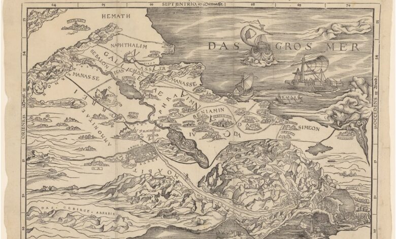
In the early 16th century, Europe witnessed a remarkable shift in how territories and borders were perceived. In 1525, an unusual map of the Holy Land was printed in Zurich, which not only challenged conventional ideas about geography but also helped shape modern perspectives on state boundaries. Created by Christoph Froschauer, this map was included in one of the first printed Bibles and proved to be a major breakthrough of its time.
Unlike the maps we are used to, where north is at the top and south at the bottom, this depiction placed the Mediterranean Sea to the east and Palestine to the west. This unusual orientation was not accidental: the creators aimed not for accuracy, but to convey the spiritual meaning found in biblical texts. The map functioned not only as an illustration, but as a tool for contemplating sacred history.
Symbols and reality
Froschauer’s map clearly marks the territories said in the Bible to have been divided among the twelve tribes of Israel. However, these lines were never meant to have political significance. They symbolized the spiritual order of the world, not actual state borders. In the Middle Ages, such images were viewed more as allegories than as precise territorial plans.
Over time, symbolic lines began to take on new meanings. When maps started to appear in Renaissance-era atlases, people began to interpret them literally. They saw in them not just religious significance, but also legal grounds for the division of land. As a result, spiritual symbols were transformed into arguments to justify territorial sovereignty.
Rethinking Borders
The question of when European states acquired their modern characteristics has long intrigued historians. In the Middle Ages, a monarch’s authority was often limited to only part of the territory, while local feudal lords enjoyed considerable autonomy. Even the king could not always intervene in the affairs of his vassals. Only with the emergence of new political ideas and the reinterpretation of ancient texts did the concept of the state as a unified space with clear borders arise.
Research at the University of Cambridge has shown that biblical maps like the Froschauer map played a key role in this process. Early modern jurists and theologians, such as John Selden, began to use biblical descriptions of the division of the Promised Land to support the idea of the nation-state. Thus, religious texts and their visual representations became tools for shaping new political concepts.
Impact on the Present
The appearance of printed maps in Bibles marked an important milestone in the development of European cartography. For the first time, a wide audience had the opportunity to see a visual representation of biblical narratives. This not only made the texts easier to understand but also helped spread new perspectives on the organization of the world.
Gradually, symbolic illustrations came to be seen as actual maps reflecting the real state of affairs. This changed attitudes toward borders and sovereignty, laying the groundwork for the formation of modern states. The Froschauer map became not just an illustration, but a significant historical document that influenced the course of European history.
Historical context
During the Middle Ages and the early modern period, state boundaries were often blurred, and power was commonly shared among various levels of authority. Maps like the one printed in Zurich helped people rethink the concept of territory. They became not only a reflection of religious beliefs but also a tool in the political struggle for power and influence.
Today, historians continue to study the influence of such maps on the development of European thought. They note that it was precisely the combination of religious symbolism and new printing technologies that changed perceptions of the world and laid the foundation for future changes to Europe’s political map.
In case you didn’t know, Christoph Froschauer was one of the most renowned printers of the 16th century in Switzerland. His publishing house in Zurich became a hub for the spread of Protestant ideas and new scientific knowledge. Thanks to his work, many important texts, including the Bible and scientific treatises, became accessible to the general public. Froschauer had a significant impact on the development of printing and culture in Europe.