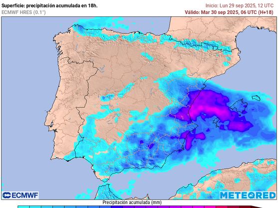
Weather conditions in Spain are once again bringing unpleasant surprises. Last night, the La Saleta ravine overflowed due to heavy rainfall, and several autonomous communities have declared an orange alert level. Meteorologists note that a combination of cold air at high altitudes and surface humidity creates ideal conditions for intense downpours and thunderstorms, which may affect the eastern and southern regions of the country, as well as the Balearic Islands.
Particular attention is now focused on Valencia and Alicante, where up to 140 liters of rainfall per square meter could fall within 24 hours. Ibiza and Formentera are forecast to receive up to 120 liters, and an orange alert is also in effect for Mallorca. Menorca remains at a yellow alert level for now, but the situation may change. There is a real risk of flooding in these areas, so local authorities strongly advise residents to exercise caution and, if possible, stay indoors.
However, instability is not limited to the Mediterranean coast. As the day progresses, storm clouds may spread to the mountainous areas of the southeast of the Iberian Peninsula, where localized but intense downpours are expected. The eastern Pyrenees are also at risk: in the afternoon, thunderstorms with torrential rain are possible. Meanwhile, in the northwest, the weather will be noticeably calmer, with skies remaining mostly clear and only light drizzle expected in the Cantabria area. The Canary Islands will see cloudy conditions and light rain in the north, with gusty winds possible in the mountains—a typical pattern for this time of year.
Temperatures will rise across most regions of Spain, although slight decreases are possible in some inland areas of Levante and on the islands. Nighttime temperatures will remain stable or dip slightly. Light frosts are not ruled out in the Pyrenean mountains, signaling the approach of winter.
Meteorologists warn that due to heavy rainfall over a short period, sudden floods, road inundations, and a sharp rise in water levels in ravines and rivers are possible. The orange alert level signals a significant risk to life and property, so residents are advised not to plan trips and to avoid outdoor activities during storms. Unstable weather is expected to persist in the coming days, although rainfall intensity will gradually decrease as the cyclone moves eastward. Authorities continue to monitor the situation and will promptly update warnings. The main priority now is to closely follow official announcements and avoid unnecessary risks.