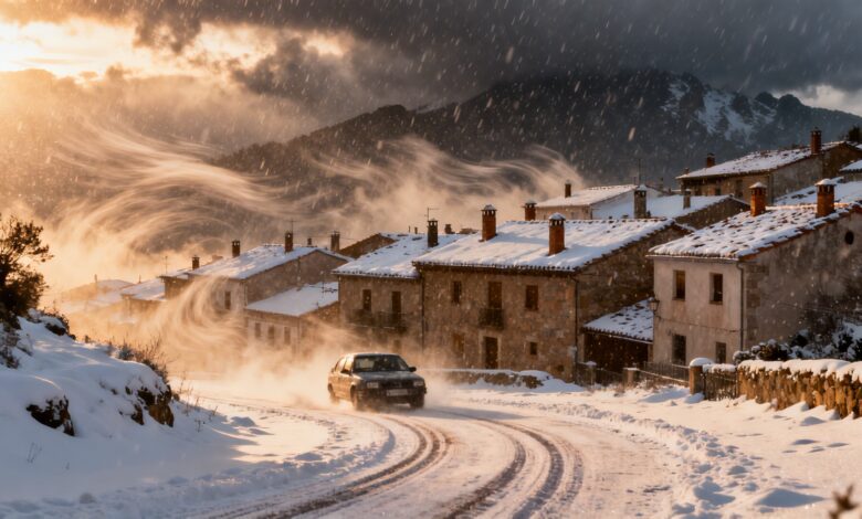
In the coming days, Spain will experience significant weather changes that will affect millions of residents. An Arctic front approaching from the northwest will bring a sharp drop in temperatures, snowfall, and heavy precipitation to various regions. These changes are especially important for those planning trips or working outdoors, as the weather conditions may impact transport, agriculture, and daily life.
According to russpain.com, the first signs of the front will appear in Galicia and Asturias as early as Friday. Rain is expected here, quickly spreading to the Cantabrian coast and the Pyrenees. Mountainous areas in the north will see snowfall, while the central regions and the Balearic Islands may experience fog and cloudiness. Temperatures will noticeably drop in the northwestern provinces, while the Mediterranean coast and the Canary Islands might see a brief increase in temperatures.
Saturday: peak of severe weather
Saturday will be the most unstable day of the week. The Arctic front will continue to move across the country, bringing heavy rainfall to northern and eastern regions. Showers and storms are possible in some areas of the northern third and the Mediterranean coast. After the front passes, even colder air will move in, leading to night frosts in mountainous areas and on the Castile and León plateau. Snowfall will persist in the northern mountains, and temperatures on the plains will approach zero.
Short-term rainfall and strong winds are also expected on Saturday in the central and eastern regions of Spain. Rain is possible in the Balearic Islands, and thunderstorms may occur in some areas. Winds will intensify in the northeast, which could disrupt road conditions and cause local transport delays.
Sunday: frost and clear spells
Overnight into Sunday, temperatures in the central and northern regions will drop to the lowest levels in recent weeks. In cities such as Salamanca, Ávila, Burgos, Teruel, Girona, Cuenca, and Ciudad Real, thermometers will approach zero degrees. A slight warming is expected during the day, especially on the Atlantic coast, but cooler weather will persist in the north and east. Strong winds are forecast to continue in the northeast, with further showers possible in some areas.
Calima—the region’s characteristic dust haze—will return to the Canary Islands, with light showers possible in the north of Tenerife and Gran Canaria. Overall, Sunday will bring clearer weather to the west and south, but the north and east of the country will remain under the influence of cold air.
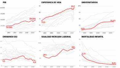
Weather anomalies in recent years
In recent years, Spain has increasingly faced abrupt weather changes at the end of winter. In 2024, a similar Arctic front brought heavy snowfall to the Pyrenees and the Cantabrian Mountains, while the cold spell in March 2025 delayed the start of spring agricultural work. According to RUSSPAIN, such weather events are becoming more frequent, requiring residents and authorities to adapt quickly to new climate conditions. Some regions have already developed special response plans for sudden cold snaps and snowfalls to minimize the impact on the economy and infrastructure.