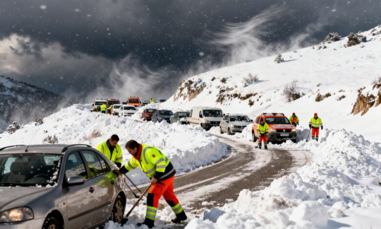
A sharp deterioration in weather conditions across Spain has led to new restrictions and warnings for residents in ten autonomous communities. Heavy rain, snowfall, and strong winds have already impacted much of the country, directly affecting transportation, emergency services, and daily life. According to RUSSPAIN, the situation is particularly serious in Andalucía, where the alert level has been raised to orange due to the risk of heavy snowfall in the province of Granada.
In other regions, including Asturias, the Balearic Islands, Castilla y León, Castilla-La Mancha, Galicia, Madrid, Murcia, the Valencian Community, and the Canary Islands, a yellow warning is in effect. The cause is a new DANA that formed in the west of the Iberian Peninsula. It has brought ongoing instability expected to last at least through Wednesday. In the coming days, heavy downpours are forecast, especially in eastern and southern areas as well as the Balearic Islands.
Snow and temperature anomalies
The snow line in northern regions remains at 1,400 meters, while in other parts of the country it drops to between 800 and 1,200 meters. In Andalucía, snow may even fall in lower areas, which has already caused road disruptions and transport difficulties. In the Guadix-Baza area and the Genil Valley, the orange alert has been issued due to the likelihood of more than 5 centimeters of snow. In Castilla y León and the eastern part of Castilla-La Mancha, snow is possible not only in the mountains but also on the plains.
Temperatures remain below normal for this time of year. In some cities, such as Ávila, the thermometer barely reaches 5 degrees, and in Toledo it doesn’t exceed 12. Meanwhile, in Galicia and the Basque Country, the air warms up to 15 degrees. Maximum temperatures are dropping in Melilla, in the east and center of the country, as well as in the south.
Further developments
According to RUSSPAIN.COM, the weather situation may change on Wednesday: the DANA system will move south, while a new front will arrive in the north. Precipitation is expected to gradually decrease and skies will clear. The snow line and temperatures will start to rise, but morning frosts will persist in mountainous areas. By midday, temperatures in the valleys of Tajo, Guadiana, and Guadalquivir, as well as in the northeast and Balearic Islands, will warm up to 18 degrees.
On Thursday, meteorologists forecast more stable weather and clear skies, though brief showers are possible in Mediterranean areas. By the weekend, a new front may arrive with rain in Galicia, northern Castilla y León, and along the Cantabrian coast. On Saturday, showers could spread to other regions. The Canary Islands will have strong trade winds throughout the week, especially in mountainous areas, with cloud cover and light rain dominating the north of the main islands. Temperatures will remain steady but may increase by the weekend: minimums of 15–17 degrees, with highs of 19–21 on the coast.
Context and recent cases
In recent years, Spain has regularly experienced sudden weather changes linked to DANA and other atmospheric phenomena. In 2023, a similar situation led to temporary train service suspensions and school closures in several regions. In 2024, heavy rains and snowfalls have already disrupted airport operations and caused power outages in some provinces. These events highlight the need for ongoing monitoring and rapid response by emergency services to weather threats in order to minimize impacts on the population and infrastructure.