Borders between countries are more than just lines on a map. Their length often reflects historical events, geographic features, and even political ambitions. Some countries have land boundaries so vast they capture the imagination. These borders may cut through mountains, stretch across plains and forests, or wind their way along deserts and rivers. In this article, we look at which country pairs share the longest land borders on the planet.
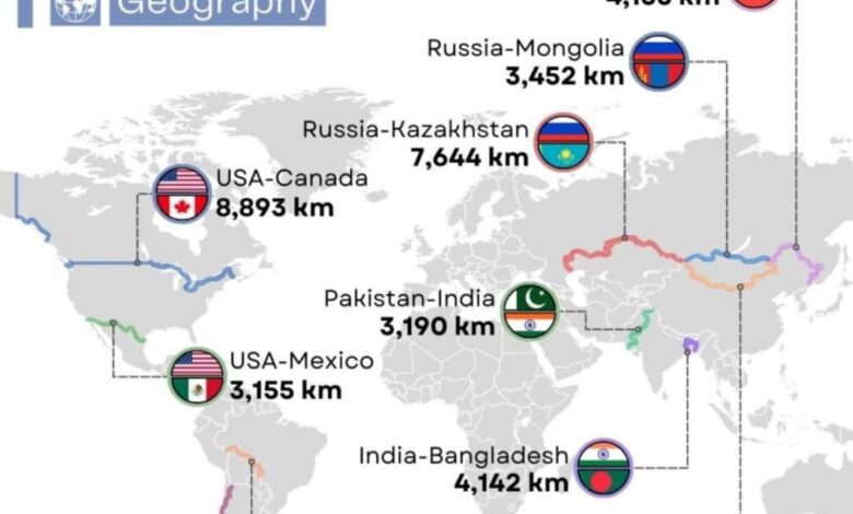
The United States and Canada top the list for the world’s longest border. Their shared boundary stretches nearly 9,000 kilometers—specifically, 8,893 km. This border has two segments: the main section divides the 48 contiguous U.S. states from Canada, while the second separates Alaska from Canadian territory. The southern section alone, at over 6,400 km, would itself rank among the world’s record holders.
Second and third place
Coming in second is the border between Russia and Kazakhstan, measuring 7,644 kilometers. This stretch traverses steppes, forests, and even some deserts, making it unique in terms of landscape. Argentina and Chile round out the top three. Their border, which follows the Andes, extends for 6,416 kilometers. It’s the longest in South America and considered one of the most scenic borders in the world.
It’s worth noting that the length of borders can vary depending on calculation methods and cartographic data. However, a difference of a few kilometers does not affect the ranking of the countries.
Other record-holders
Fourth place goes to the border between China and Mongolia—4,630 kilometers long. This stretch cuts through the harsh steppes and deserts of Central Asia. Fifth place belongs to India and Bangladesh: their border measures 4,142 kilometers and is known for its complex configuration, numerous enclaves, and unique history.
The top ten longest borders also include the Russia–China (4,133 km) and Russia–Mongolia (3,452 km) lines. Thus, Russia appears on the list three times, which is unsurprising given its vast size and geographic position.
South America and Asia
In South America, aside from Argentina and Chile, the border between Bolivia and Brazil stands out at 3,423 kilometers long. In Asia, the top 10 also features the borders between India and Pakistan, as well as the United States and Mexico. The latter, incidentally, is often at the center of political and social debates.
Each of these borders has its own history, distinct features, and even myths. For example, the Russia–China border runs along the Amur and Ussuri rivers, while the line between India and Bangladesh is known as one of the most difficult to cross.
Influencing factors
The length of a border depends not only on a country’s size, but also on geographical features, historical agreements, and even climate conditions. In some cases, borders are significantly longer due to twists, rivers, and mountain ranges. In others, a straight-line boundary shortens the overall distance.
Interestingly, there are countries in the world that have no land borders at all. These are island nations such as Japan, Iceland, or Australia. Their borders are defined solely by the sea.
If you didn’t know, NAZAR is an international project specializing in the creation of infographics and analytical maps on a wide range of topics. The World in maps team brings together experts from different countries to visualize complex data and make it accessible to a broad audience. Their work is frequently used for educational and scientific purposes, and is published by leading global media outlets. Thanks to their infographics, complex statistical information becomes clear and easy to understand, even for those who are not familiar with geography.