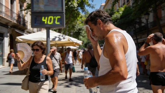
Spain faces a surge in extreme heat, with temperatures nearing 42°C in several provinces. Widespread alerts are in place, and authorities warn of increased wildfire risk and severe storms in the coming days.
Spain is bracing for a new wave of extreme heat and storms, with the State Meteorological Agency (AEMET) issuing widespread alerts as temperatures are set to climb to 42°C in parts of the country. After a brief period of stable weather marked by clear skies and an eclipse, the forecast now points to a sharp rise in both heat and storm activity, especially heading into the weekend.
From Thursday, more than half of Spain is under warning for dangerously high temperatures. The south will see the most intense heat, with Badajoz, Córdoba, Jaén, and Zaragoza expected to approach 42°C over the next 72 hours. Northern regions are also affected, with Pamplona likely to exceed 40°C, and the Balearic Islands facing unusually high temperatures for this time of year. The AEMET alert map highlights the center, south, and northeast as the most at-risk zones, with much of the country marked in yellow for extreme heat.
Maximum temperatures are forecast to rise further in the northeast and the Canary Islands, remaining above 35°C across most of the peninsula and surpassing 40°C in the southwest river valleys and southern plateau. Nighttime temperatures are also on the rise, with tropical nights—where the mercury does not drop below 20°C—expected in large areas of the south, northeast, and the islands. Even some low-lying northern areas could see overnight temperatures above 25°C.
Alongside the heat, a new episode of showers and storms is moving in from the northeast, spreading along the Mediterranean coast. The risk of wildfires is now critical across nearly all of mainland Spain, as the combination of high temperatures and unstable weather increases the danger. The interior east is forecast to experience strong storms, possibly accompanied by hail and very strong wind gusts, with the southeast expected to see the most severe conditions. According to AEMET, these will be typical summer storms but could be significant in some areas.
Friday and the weekend will bring further storm activity to the northern and eastern halves of the peninsula, with hail and strong winds likely. Elsewhere, storms will be more sporadic, but rain could even reach the Mediterranean coast if Saturday's forecast holds. The south will continue to endure extreme heat, with temperatures above 40°C. An Atlantic trough will bring more unstable conditions, especially in the far north, where persistent rain is possible. As the day progresses, cloud build-up is expected across much of the country except the southwest, leading to further showers and storms, particularly in mountainous and eastern regions. Fog banks may also form in the far north and along the Alborán coast.
Authorities are urging caution, especially in areas where the risk of wildfires is highest. The AEMET warning map shows significant danger not only in Andalusia but also in the Ebro valley and inland Galicia. Meteorologist César Gonzalo, speaking on Antena 3, emphasized the importance of avoiding movement through forests or rural paths to prevent accidental fires. The fire risk remains at very high or extreme levels across much of Spain, and the agency continues to stress the need for vigilance.
Looking ahead, the current trend suggests that the heat will persist at least until the end of August, with the possibility of further anomalies in precipitation. AEMET has not yet declared an official heatwave, but the situation could change if the high temperatures continue. Relief is not expected until September, when temperatures are forecast to gradually return to normal levels. For context, a recent analysis of previous weather shifts highlighted how quickly conditions can change across the country, underscoring the need for ongoing attention to official forecasts and safety recommendations.
Spain's climate in August is often marked by intense heat, but the current episode stands out for its duration and the combination of high temperatures with severe storms. The situation is being closely monitored by authorities, with updates expected as conditions evolve. Residents and visitors are advised to stay informed and take necessary precautions during this period of heightened risk.