A rare Atlantic storm is set to disrupt weather across northern and eastern Spain. Authorities have issued rain and storm alerts for several regions. Temperatures are expected to drop sharply in affected areas.
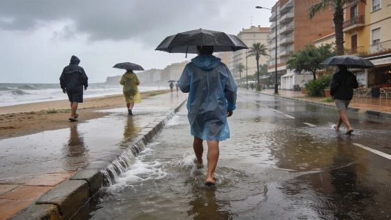
Spain faces a significant weather shift as an atypical Atlantic low-pressure system approaches the peninsula, bringing heavy rainfall and storms to the north, east, and Balearic Islands. The Spanish State Meteorological Agency (Aemet) has issued multiple alerts, with Catalonia under orange warning for intense rain and yellow for storms, while Baleares, Cantabria, and the Basque Country are on yellow alert for rainfall. The storm, monitored by the US National Hurricane Center due to its unusual characteristics for August, is expected to impact large areas over the coming days.
Early Friday, the system’s effects were already visible. After severe storms battered the Valencian Community and southeast Spain on Thursday, the focus shifted overnight to the Balearic Islands. Menorca recorded wind gusts up to 121 km/h, intense rainfall of seven liters per square meter in just ten minutes, and a rapid temperature drop of nearly 10°C. By afternoon, Tarragona was bracing for up to 100 liters per square meter in accumulated rainfall. The storm’s trajectory suggests that by Saturday, the interior of northern Spain will see increased activity, with Galicia expected to receive the first rains linked to the system by Sunday evening.
According to Aemet spokesperson José Luis Camacho, Friday will see further showers and storms in Mediterranean and nearby regions, driven by wind patterns. The Cantabrian coast, especially eastern areas, will experience persistent cloud cover and locally strong showers, with up to 15 liters per square meter possible in coastal Cantabria and the Basque Country. Afternoon development of storm clouds is likely in northern inland areas and the Balearics, potentially triggering thunderstorms in the Aragonese Iberian system, Baleares, Barcelona, and Girona.
Forecasts for Friday afternoon indicate showers along the Catalan coast and Balearic Islands, some with strong thunderstorms. Persistent rain is expected on the Cantabrian and Basque coasts. By late evening, heavy and persistent precipitation is forecast for southern Catalonia, possibly extending into Saturday morning and affecting the coasts of Castellón and Barcelona. The orange alert in Catalonia specifically targets the northern and southern Tarragona coast, where rainfall could reach 100 liters per square meter in successive downpours.
Elsewhere in Spain, skies will remain mostly clear, except for the Canary Islands, where the north may see clouds and light rain. Maximum temperatures will drop notably in the northern plateau, northeast, and Mediterranean, especially in the Iberian system, Castellón, and Baleares, while rising in the southwest. Minimum temperatures will generally decrease, with little change in the Canary Islands. The risk of wildfires has decreased to low or moderate in most regions, though remains high in Galicia, the northeast, and southern Mallorca.
Saturday is expected to bring further complications as the rare Atlantic low, possibly with subtropical features, moves closer to Portugal and northwest Spain. While not classified as a hurricane, its structure has drawn attention from international meteorological agencies. Portugal may even assign it the name Vitor if it intensifies further. The upper-level trough, a mass of colder air at higher altitudes, will reinforce instability as it shifts toward the peninsula, pushing storms into the northern interior. The day will start with a continuation of Friday’s conditions—strong, persistent showers along the Tarragona, Barcelona, and Castellón coasts, extending into the afternoon. The eastern third of the peninsula and Baleares will remain cloudy, while the Cantabrian region, Galicia, and the northern plateau will see daytime cloud development. Strong storms are forecast for the Ebro valley and the Iberian system, with up to 20 liters per square meter and possible hail and strong winds. The Canary Islands will see cloudy skies in the north and clearer conditions in the south.
Weather alerts for Saturday keep Catalonia on orange for rain and yellow for storms, with yellow warnings for both rain and storms in Aragón and the Valencian Community. Maximum temperatures will rise in most areas except for the Levante, Baleares, Catalonia, and the Canary Islands, where they will fall. Minimum temperatures will rise slightly in central Spain and decrease elsewhere and in the islands. The wildfire risk will increase again, reaching moderate to high in many regions, and very high in Galicia and the interior, especially the two plateaus and Aragón.
By Sunday, the storm system will approach the Atlantic coast, directly affecting Galicia and the southwest by evening with rain in the Rias Baixas. The upper-level trough will cross the peninsula, bringing southerly winds and increased instability. Western Spain will see cloudier skies, and southerly winds will raise temperatures in the Basque Country. The Mediterranean will continue to experience humidity-driven storms, particularly in the Ebro valley and inland Valencia. Temperatures are expected to rise in many areas, especially in the north. No weather alerts are currently in place for Sunday.
Looking ahead, forecasts suggest that Monday could bring widespread rain to the northwest, including Galicia, Asturias, Castilla y León, and Extremadura, with isolated showers in western Andalusia and central regions. Strong storms are also possible in La Rioja, Navarra, Aragón, Catalonia, the Valencian Community, Murcia, eastern Castilla-La Mancha, and Baleares. Galicia, Cáceres, Aragón, and Catalonia could see particularly intense rainfall. The final week of August is likely to be cooler and wetter than usual in western Spain, according to Aemet’s weekly outlook.
Recent weeks have seen several unusual weather events across Spain, including sharp temperature drops and heavy rainfall. For example, a previous episode brought autumn-like conditions to many regions, highlighting the volatility of this summer’s weather patterns. Such shifts underline the importance of staying updated on official forecasts and regional alerts, especially as the Atlantic system continues to evolve.