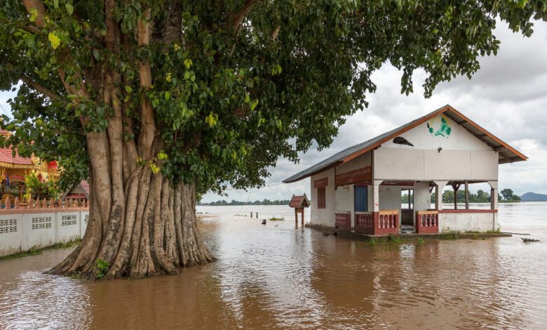
The summer of 2025 will forever remain in the memory of US residents as the season when familiar weather patterns were completely upended. The central and eastern states found themselves at the heart of severe downpours that literally flooded cities and towns. In Texas, Kentucky, and several other regions, the disaster claimed hundreds of lives, with colossal damage to infrastructure and the economy. Meanwhile, despite all forecasts, not a single powerful hurricane reached the US coastline—all of them moved out into the open Atlantic Ocean.
What caused such an unusual and devastating summer? The answer lies in the behavior of the polar jet stream—a powerful river of air that usually shifts far to the north in summer, leaving most of the US relatively calm. In 2025, the jet stream unexpectedly dipped much farther south than usual and weakened, triggering a whole chain of catastrophic consequences.
Jet Stream Anomaly
In typical years, the jet stream weakens and shifts toward Canada in the summer, making rainfall in the US mostly local. But in 2025, not only did it fail to move northward, it became far more meandering. Instead of quickly pushing cyclones east, it trapped them over the same regions. As a result, downpours lasted for hours and sometimes days, causing flash floods.
The weakened jet stream began to behave unpredictably: its waves would surge north, then suddenly dip south, allowing humid air from the Gulf of Mexico to flood deep into the continent. Atmospheric moisture reached record highs, and each new cyclone brought even more precipitation. In some areas, an entire month’s rainfall fell in just one day.
Humidity and heat
The situation was exacerbated by unusually high water temperatures in the Atlantic and the Gulf of Mexico. Warm seas evaporate more moisture, and heated air can hold far greater volumes of it. In 2025, these two factors acted as catalysts, pumping vast amounts of water vapor into the atmosphere—immediately turning into torrential downpours.
Constant waves of humid ocean air collided with cyclones stalled over the continent. As a result, the same regions were drenched again and again—rainfall that would normally be spread across different areas. In some cities, floodwaters on the streets rose waist-high, forcing residents to seek refuge on rooftops.
Hurricanes and their tracks
While the central states were submerged, the hurricanes that usually menace the coasts behaved differently in 2025. All five major tropical cyclones—including three category 5 storms—skirted the U.S. mainland altogether. The reason: the same jet stream, coupled with a weakened Atlantic anticyclone, that quite literally steered storms out to sea.
Out of 13 tropical storms and hurricanes, only a few even approached the Caribbean. The rest veered northeast, causing no damage to Florida or other coastal states. For meteorologists, this was a real mystery; for coastal residents, it was an unexpected relief against the backdrop of disaster in the country’s interior.
Climate impact
Climate change has a direct impact on jet streams. The Arctic is warming twice as fast as the rest of the world, and the temperature difference between the equator and the pole is narrowing. This weakens the jet streams, making them more meandering and prone to getting stuck in one place. In 2025, that’s exactly what happened: the jet stream not only weakened, but also became ‘locked in’ over the same regions.
Scientists note that such blockages now occur three times more often than in the mid-20th century. This means that extreme weather events—whether downpours, droughts, or heatwaves—will happen increasingly often and become even more destructive. Water and heat are now the new reality for millions of Americans.
What’s next
While scientists debate the details, one thing is clear: the jet stream will continue to shape the weather in the coming years. In winter, it typically strengthens and dips even further south, bringing blizzards, freezing rain, and sharp cold snaps. But if the weakening trend continues, we could see even more unpredictable weather disasters ahead.
The question isn’t whether we’ll see a summer like this again, but when it will happen and how severe the consequences will be. Are cities and infrastructure prepared for these new challenges? There is no answer yet, but one thing is clear: the weather we’re used to is becoming a thing of the past, and new climate risks demand urgent action.
RUSSPAIN reminds us that the jet stream is a powerful air current at an altitude of 8–12 km that drives weather systems around the globe. Its behavior depends on the temperature difference between the equator and the pole. In recent years, jet streams have become increasingly unstable, leading to more extreme weather events across all continents.