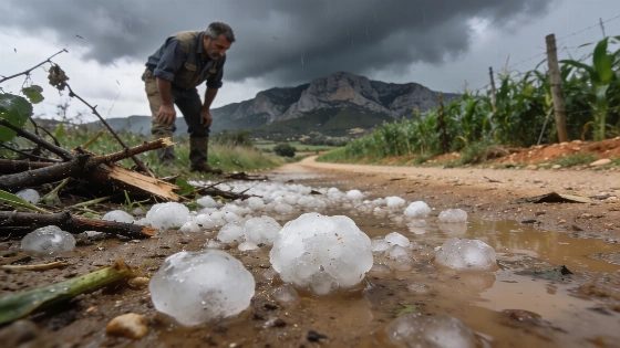
A powerful hailstorm struck the interior of Valencia, with hailstones as large as mandarins. The storm caused significant disruption in rural areas, affecting crops and local infrastructure. Emergency teams remain on alert.
Large hailstones battered several areas of inland Valencia on Thursday afternoon, as two intense storm cells swept across the Comunitat Valenciana. According to the Agencia Estatal de Meteorología (Aemet), one storm developed over els Ports in northern Castellón, while another, more severe cell moved slowly through the southern interior of Valencia, bringing heavy hail and localized downpours.
The most affected zones included Muela de Cortes and the Caroig Massif, where the storm advanced eastward, impacting the Canal de Navarrés. The Associació Valenciana de Meteorologia (Avamet) highlighted that the hail near Caroig reached the size of mandarins, sharing images from the Grupo Pronto Auxilio de Ayora that showed the scale of the ice stones. Additional hail was also reported in the Llosa de Ranes area.
Emergency teams from Grupo Pronto Auxilio Ayora maintained storm surveillance throughout the afternoon, noting that while lightning strikes hit the ground in the Valle de Ayora, rainfall remained minimal. Despite dramatic skies, precipitation in Ayora itself was limited, underscoring the highly localized nature of these summer storms.
Rainfall data from Avamet's monitoring network showed the heaviest accumulations in the northern interior of Castellón, with Morella, Villores, and La Mata each recording over 24 liters per square meter. In contrast, most of inland Valencia saw lower totals, except for Bicorp, which registered 19.6 liters. Other towns such as Yátova, Cortes de Pallás, Requena (Casas del Río), Macastre, and Alborache reported between 11 and 15 liters, while Buñol, Chella, Serra, Teresa de Cofrentes, Chelva, and Anna saw even less. The brief but intense hailstorm in Llosa de Ranes and other parts of La Costera left visible ice but little lasting rainfall.
Aemet confirmed that the storm cell over southern Valencia, which produced short-lived but intense hail, moved out to sea via the Valldigna area around 19:30. However, new storm cells continued to form in the northern interior, with reports of hail in Los Pedrones, south of Requena. By 20:00, the city of València itself experienced a thunderstorm with lightning, but rainfall totals in urban neighborhoods such as Camins al Grau, Patraix, Albors, Penya-Roja, and Corts barely exceeded one liter per square meter.
These weather events follow a pattern of increasingly volatile summer storms in the region, which have caused significant agricultural and infrastructure damage in recent years. The Generalitat Valenciana has previously allocated emergency funds to support affected communities, as seen when direct aid was provided to towns hit by wildfires in Castellón. Local authorities and meteorological agencies continue to monitor storm activity closely, warning residents to remain vigilant during periods of unstable weather. Hailstorms of this magnitude can devastate crops, damage vehicles and roofs, and disrupt rural life, making rapid response and accurate forecasting essential for minimizing losses.
For context, the Comunitat Valenciana is particularly vulnerable to sudden convective storms during the summer months, with inland areas often experiencing the most severe impacts. The combination of mountainous terrain and warm, humid air masses can trigger rapid storm development, leading to unpredictable and sometimes destructive weather patterns. Residents are advised to follow updates from Aemet and local emergency services during periods of heightened risk.