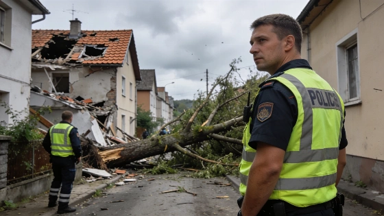
A powerful storm system brought heavy rain, hail, and strong winds to Germany. Westerwald suffered major damage and power cuts. Authorities warn of ongoing tornado risk and further storms overnight.
Germany faced a wave of severe storms on Wednesday, with intense rainfall, hail, and damaging winds sweeping across several regions. The Westerwald area in Rhineland-Palatinate was among the hardest hit, where emergency services responded to widespread destruction, including collapsed roofs, uninhabitable homes, and blocked roads. Power outages affected parts of Montabaur and Niederahr, while two people were seriously injured by a falling tree in the Mayen police district.
Throughout the evening, a line of thunderstorms moved eastward from Belgium and Luxembourg, bringing further risk of tornadoes, especially between Erfurt, Jena, and Weimar. Meteorological data indicated wind gusts reaching up to 108 km/h on the Wasserkuppe, with the potential for even stronger bursts in areas not directly monitored by weather stations. The storm cell responsible for much of the damage had tracked from Belgium through the Eifel and Westerwald, maintaining its intensity as it advanced.
Air traffic at Frankfurt Airport experienced delays due to the adverse weather, while heavy rain and hail were reported from the Mosel to the Saarland. In North Rhine-Westphalia and Rhineland-Palatinate, rainfall totals exceeded 30 liters per square meter in some locations by 20:00. Thunderstorms also developed in Thuringia and continued to move east, raising concerns for further local flooding and wind damage.
As the night progressed, the risk of severe weather persisted, particularly in Saxony, where storm warnings remained in effect into the early hours. Rain and isolated thunderstorms were expected to continue from Hesse to the Uckermark, while other regions saw a lull in activity. Temperatures overnight ranged from 14°C along the Baltic Sea to a warm 22°C in the Upper Rhine area.
Looking ahead to Thursday, meteorologists forecast a split weather pattern: the northern half of Germany is likely to see sunshine mixed with showers, while the south will experience less heat but continued thunderstorm activity. The northwest and southern regions remain unstable, with the possibility of further heavy downpours. In contrast, areas from Saarland to southern Brandenburg are expected to enjoy a calmer mix of sun and clouds.
Wednesday's events highlighted the sharp contrasts in weather across the country, with the south experiencing summer-like temperatures above 30°C and the north seeing autumnal conditions around 15°C. Earlier in the day, strong winds were already noticeable in the southern half and along the coasts, with gusts reaching 50 km/h. The situation follows a broader trend of extreme weather in Europe, as seen recently when Spain faced a surge in temperatures and heightened fire risk after a DANA event, as reported in coverage of Spain's heatwave and storm alerts.
For context, Germany's varied geography often leads to significant weather contrasts, especially during transitional seasons. The Westerwald, with its dense forests and hilly terrain, is particularly vulnerable to wind and storm damage. Local authorities regularly update residents on severe weather risks, and the German Meteorological Service provides real-time radar and warnings. As climate patterns shift, such extreme events may become more frequent, underscoring the importance of preparedness and timely information for affected communities.