Spain faces a sharp rise in temperatures after the latest DANA. Authorities warn of extreme heat, storms, and wildfire risk. Weather alerts cover much of the country this week.
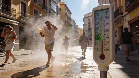
Spain is bracing for another surge in temperatures just days after the latest DANA brought temporary relief. The State Meteorological Agency (Aemet) reports that a ridge of high pressure is moving over the northern half of the peninsula and the Balearic Islands, triggering a rapid increase in daytime highs. This new heatwave is expected to last until midweek, with maximum temperatures exceeding 35°C in large parts of the south, northeast, Madrid, Galicia, and even reaching 40°C in the Guadalquivir and Tajo valleys.
Monday brings a mix of weather: overcast skies and light rain in the Cantabrian region, lingering low clouds in the Strait, Ceuta, and Melilla, and the development of storm clouds over central, southern, and eastern mountain areas as the day progresses. Aemet warns of possible heavy showers and thunderstorms, with strong winds and hail, especially in Extremadura, Castilla-La Mancha, the Baetic Systems, Cádiz and nearby areas, the lower Ebro, and the Pyrenees. Localized downpours could deliver 15 to 25 liters per square meter in an hour in provinces such as Cádiz, Málaga, Castellón, Teruel, Barcelona, and Girona. The Canary Islands will see cloudy intervals and occasional rain on the mountainous islands.
Thermometers will climb across the interior, remain steady on the coasts and Balearics, and dip slightly in the Canaries. Nighttime lows will rise in central Spain, stay unchanged elsewhere, and only drop in the north. The risk of wildfires remains very high or extreme in Galicia, western Castilla y León, Extremadura, southern and eastern Castilla-La Mancha, eastern Andalusia, the Mediterranean area, and the Balearic Islands. In contrast, the Canary Islands face only low to moderate fire risk. Weather alerts are active in ten regions, including yellow warnings for rain and storms in Andalucía, Aragón, Catalonia, and the Valencian Community, and orange warnings for heat in Andalucía.
On Tuesday, high temperatures will persist in Galicia, much of central and southern Spain, the Ebro valley, and Catalan depressions. Most areas will see clear or mostly clear skies, except for some low clouds in the Cantabrian region and the Strait, Ceuta, and Melilla, which are expected to clear. Afternoon instability could again trigger isolated storms in interior mountain systems and the Pyrenees. The Canary Islands may experience increased cloudiness and light rain on mountainous islands. Maximum temperatures will rise in the north, Málaga, the southeast, and the Canaries, while the southwest and Balearics may see stable or slightly lower readings. Tropical nights, with lows above 20°C, will continue in the southwest, Mediterranean coasts, and parts of the Cantabrian northeast, with some Mediterranean areas not dropping below 25°C. Wildfire risk remains high or extreme in much of the north, the Mediterranean, Balearics, central Spain, and Extremadura.
By Wednesday, a trough and an Atlantic front will approach, absorbing the remnants of the previous DANA and marking the start of a significant weather shift. From midday, storm clouds will build across much of the peninsula, with probable showers and thunderstorms in the Pyrenees, Baetic Systems, northern Iberian System, and Cantabrian Mountains. These storms could be intense, with strong gusts and hail, and may extend to lower areas or the southeast. The Canary Islands will again see cloudy intervals and possible rain on mountainous islands. Maximum temperatures will generally fall, except for rises in Valencia, Catalonia, and the Balearics, where highs could reach 38°C in Valencia and Alicante. Minimum temperatures will drop in Galicia, the Cantabrian region, and the southwest, but rise elsewhere, leading to more tropical and torrid nights, especially along the Mediterranean coast and in the northwest.
Looking ahead to Thursday and Friday, the arrival of a trough and a cold Atlantic front will bring a widespread drop in temperatures and rain to many parts of Spain. This shift follows a period of unstable weather, which, as previously reported in recent severe storm warnings for northern and eastern Spain, has kept much of the country on alert. The ongoing pattern highlights the volatility of Spain's summer weather, with rapid transitions between heatwaves, storms, and fire risk. For residents and authorities, the coming days will require close attention to official advisories and local conditions as the situation evolves.
Spain's climate in recent years has been marked by increasingly frequent and intense heatwaves, often interrupted by short-lived episodes of instability such as DANAs (isolated high-altitude depressions) and troughs. These patterns not only challenge emergency services but also impact agriculture, tourism, and daily life. The combination of high temperatures, dry conditions, and strong winds significantly raises the risk of wildfires, particularly in regions with dense vegetation or prolonged drought. Authorities continue to urge caution, especially in areas under weather alerts, and recommend following guidance on heat protection and fire prevention. The unpredictability of summer weather underscores the importance of timely information and preparedness across the country.