Severe storms have swept across Spain, leaving three dead and breaking rainfall records. Nine regions remain under alert as experts question if the Mediterranean is seeing new, tropical-like weather patterns.
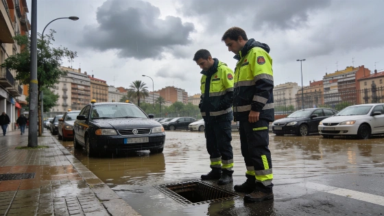
Vilassar de Dalt, a town in Barcelona province, took a direct hit. In just six hours, 176 litres of rain fell per square metre. Since midnight Friday, the total reached 226 litres. Other parts of Barcelona saw similar extremes. Drassanes station logged 202 litres. The Olympic Port observatory measured 50.4 litres in a single day. These numbers stunned meteorologists. The storms have already claimed three lives: an elderly woman in Madrigueras (Albacete) on Saturday, and two more in Barcelona on Sunday.
Monday morning brought more trouble. The Agencia Estatal de Meteorología (Aemet) raised a red alert for the Barcelona prelitoral. This is the highest warning. Stationary storms threatened Granollers. Meteocat reported 92 litres per square metre in under an hour. That made it five days in a row with maximum alert in Catalonia. The crisis dragged on. By 11:00 on October 5th, Granollers had seen 98 l/m² of rain. Half of that—50 l/m²—fell in just 30 minutes. The total for the episode reached 346 l/m². Regional authorities confirmed the numbers. The rain just kept coming.
Catalan authorities sent an ES-Alert emergency message to residents of Vallès Oriental and Maresme due to the risk of sudden flooding, while AEMET warned of over 90 l/m² of rain per hour in the Granollers area.
The worst of the rain eased, but danger lingered. Nine autonomous communities stayed under weather warnings. Catalonia, Castilla y León, Castilla-La Mancha, and Extremadura faced orange alerts for serious risk. Asturias, Baleares, Galicia, Madrid, and Murcia were on yellow alert for storms or heavy rain. The culprit: a 'dana', an isolated high-altitude depression, hovered west of Portugal. It kept sending moisture and energy over Spain. The Catalan Water Agency reported the Besòs river at Santa Coloma de Gramenet went above its danger level. All entrances to the Besòs river park closed. Overflow was a real threat.
Forecasts from Aemet spokesperson Rubén del Campo pointed to more trouble ahead. He warned of more showers and storms, some with hail. Temperatures would drop from Tuesday. An unseasonably cool spell was coming, but a rebound was expected by the weekend. The Mediterranean coast would heat up. The Guadalquivir valley could hit 32°C. AEMET had warned as early as September 30th about very heavy, long-lasting rain from Thursday through October 5th. Castellón, Valencia, northern Alicante, and nearby areas could see over 150 l/m² in less than six hours. Flash floods were a real risk.
Tuesday looked stormy. Showers were likely across most of Spain, especially in the north and central regions. Extremadura, western Castilla-La Mancha, and the Sistema Central were flagged for heavy rain and hail. The Balearic and Canary Islands would not escape. Scattered showers and calima were forecast for the Canaries.
The Catalan Civil Protection confirmed two fatalities: one person died in Tordera after a campsite wall collapsed, and another drowned in the parking lot of their home in Montmeló/Montornès del Vallès. There were also reports of a missing person in Pineda de Mar, possibly swept into a river channel.
By Wednesday, the cool-down would deepen. Northern Spain and the Canary Islands would feel it most. The heaviest rain would shift north. The Cantabrian coast, northeast, and Balearic Islands braced for more storms and hail. The west and south would clear up. But the north of the Canary Islands still faced rain.
Later in the week, things would calm. From Thursday, more stable, anticyclonic weather was expected. The far north, Catalonia, and the Balearic Islands could still see strong showers. By the weekend, rain should ease. Temperatures would start to recover, but stay cool for October.
But the story runs deeper than numbers. Aemet’s Rubén del Campo pointed to the Mediterranean’s record warmth. At the end of September, the Balearic Sea was over 26°C—a record for the time of year. This heat gave storms extra fuel. More evaporation meant more humidity. That powered the convective storms that battered the region. Classic triggers like a strong 'dana' or trough were missing. Still, the storms hit hard. Meteorological sources said the DANA system formed west of Portugal. The warm Mediterranean loaded the air with moisture and energy. That made the storms, hail, and lightning worse.
Sunday broke an October record for lightning. There were 83,230 strikes across Spain. The scale and frequency of the storms raised new questions. Some meteorologists wondered if Spain was seeing something like tropical cyclogenesis. Juan José González Alemán of Aemet said the extreme event in Catalonia was “consistent with a process of tropical cyclogenesis, that is, a genuine attempt at tropical cyclone formation from a cluster of very strong storms.” If true, this would be a first for the Mediterranean. It could change climate science in the region.
Other experts, like Ángel Rivera and climatologist Samuel Biener, said more study is needed. They pointed to similarities with tropical systems and the possible role of mesoscale convective vortices as seeds for new cyclones. The Catalan branch of Aemet urged caution. Still, they admitted the event was unusual. They also noted that climate change is warming Mediterranean waters and making rainfall extremes worse.
Now, Spain’s hardest-hit regions wait and watch. The worst flooding may be over, but last week’s weather exposed new risks. Record sea temperatures, stubborn atmospheric instability, and the threat of tropical-like storms are changing the game. For officials and residents, the message is simple. Spain’s weather is shifting. Adapting will take vigilance and science.