Scientists still lack basic ocean and seabed data from the Wilkes Subglacial Basin. The ice beneath East Antarctica could raise global sea levels by up to four metres.
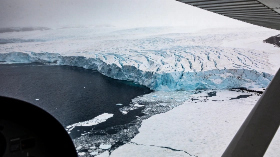
No research vessel has come within 150 kilometres of the front of Cook Glacier. There are no direct maps of the seabed in front of it. That gap now sits at the centre of concern over the Wilkes Subglacial Basin.
The basin contains enough ice to raise the global average sea level by between three and four metres. It has received far less direct study than West Antarctica, despite signs that it may be one of East Antarctica's most vulnerable areas.
The problem is basic. Scientists need observations.
They still do not know whether relatively warm ocean water reaches the glaciers. The shape of the seafloor beneath the ice-covered continental shelf is also unclear. So is the distance to a warming threshold that could trigger large-scale retreat.
Matt King of the University of Tasmania and the Australian Centre for Excellence in Antarctic Science described the Wilkes Subglacial Basin as "perhaps the last unexplored place in Antarctica" and called for a coordinated, long-term international research programme.
A review in Nature Reviews Earth& Environment brings together evidence from geology, oceanography, climate science, satellite observations and ice-sheet modelling. Published on 30 September 2026, it calls for an urgent international programme to observe and map the basin.
The team includes Dimitris Evangelinos of the Marine Geosciences Research Group at the University of Barcelona and specialists from 14 countries. Matt King of the Australian Centre for Excellence in Antarctic Science and the University of Tasmania led the study, according to materials from the University of Tasmania and ACEAS.
The blind spot is unusual, even by Antarctic standards.
The basin stretches roughly 1,400 kilometres from east to west and 400 kilometres across. Its ice sits on bedrock more than 2,000 metres below sea level. Sea ice covers much of the nearby continental shelf for much of the year. In some areas, it is exceptionally thick. Access and measurements are difficult.
The 30 September 2026 review argues that the basin needs a coordinated, multi-year international programme of direct observations and mapping. The authors say that the shortage of measurements currently prevents scientists from reliably identifying when, or under what conditions, large-scale retreat could begin.
The bedrock shape adds to the risk. It deepens inland instead of becoming shallower. That reverse slope can support marine ice-sheet instability. If the grounding line moves beyond certain stabilising points, retreat may speed up.
Models cited by the researchers indicate that movement could reach approximately one kilometre per year under some conditions.
The ocean could turn that vulnerability into lasting ice loss.
Comparatively warm seawater can enter cavities beneath floating ice shelves. Melting from below then makes the shelves thinner. The glaciers behind them face less restraint.
Existing observations already show decades of grounding-line retreat, thinning ice shelves and partial collapse in parts of the region. The speed and final scale of any wider change remain uncertain.
That uncertainty matters.
Paleoclimate records and simulations show major ice retreat in the area during some warmer periods, particularly the Pliocene. Researchers still cannot say which climate thresholds would trigger a large-scale retreat, how quickly it would develop or how much the basin would add to global sea-level rise.
Wilkes is not the only concern. The Aurora and Recovery basins also contain marine-based ice that may be exposed to ocean warming. Together, these East Antarctic basins hold enough ice to produce a potential 19-metre rise in the global average sea level.
The effects would reach beyond coastlines. Extra freshwater in the Southern Ocean could affect deep-water formation around Antarctica. It could also alter ocean circulation, biogeochemical cycles and marine ecosystems worldwide.
Australia has a direct strategic interest. Wilkes is the closest major East Antarctic basin to the continent. Projections cited in the review put the cost of sea-level rise to Australia at about 855 billion dollars this century. Around 85% of the country's population lives in coastal areas.
The Scientific Committee on Antarctic Research has approved an action group to coordinate research planning. One country working alone could need 20 to 30 years to understand the basin properly.
Officials have little time.
The scientific case rests on speed and cooperation. Waiting for clearer damage would delay the work needed to understand the risk.
Wilkes has shifted from a remote research gap to a measurable climate risk. The evidence does not establish an imminent collapse. It does show that ocean access, hidden bedrock geometry and past retreat patterns need immediate investigation.
East Antarctica cannot be treated as stable by default. Without coordinated observations, future sea-level exposure may be calculated only after the most important warning signs have appeared.