A new Atlantic storm will bring intense rain and storms to northwest Spain. Authorities warn of severe weather in Galicia and Asturias, with sharp temperature contrasts across the country. Fire risk remains high in several regions.
Spain faces another round of severe weather as a new Atlantic storm system approaches from the west, set to impact the country on Wednesday and Thursday. The State Meteorological Agency (Aemet) warns that the northwest, especially Galicia and Asturias, will see the most intense rainfall and thunderstorms, while the rest of the country will experience a dramatic split in temperatures between east and west.
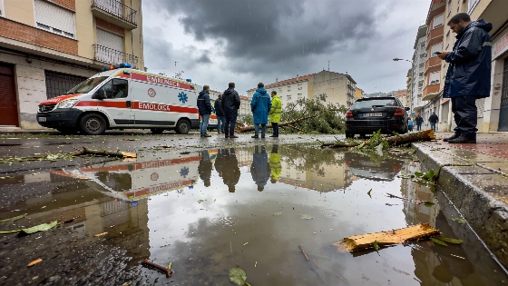
On Tuesday, the focus shifted from the eastern regions, which had just endured violent storms and hail in Catalonia and Aragón, to the northwest. In Tarragona, hailstones reached up to nine centimeters in diameter, causing widespread damage, including uprooted trees, flooded homes, and disrupted transport. The capital saw over 77 liters of rain per square meter in 24 hours, with sudden temperature drops and strong wind gusts. In Cerler (Huesca), storm-driven winds reached 109 km/h.
While the Mediterranean coast and Balearic Islands enjoyed stable weather and high temperatures, the northwest braced for worsening conditions. Aemet forecasts locally strong showers and storms in Asturias and northeast Galicia, with up to 15 liters of rain per square meter in just one hour. Maximum temperatures are expected to fall sharply in Galicia and the Cantabrian coast, dropping by at least six degrees in some areas, while the Mediterranean and Andalusia could see highs above 35°C. Minimum temperatures will generally decrease, except along the Mediterranean coast, where warm sea temperatures keep nights mild. The risk of wildfires remains very high in the eastern interior, eastern Catalonia, and the Balearic Islands.
By Wednesday, the storm system northwest of Galicia will intensify, sending a cold front across much of Spain. This will bring persistent rain and thunderstorms, especially to western Galicia, with accumulations of up to 40 liters per square meter in 12 hours. Strong winds are expected in the northern mountains and the northern plateau, while the Ebro valley, eastern Cantabria, and the Balearic Islands will see a notable rise in maximum temperatures, exceeding 35°C in some inland areas. The sharp thermal contrast and advancing front could trigger intense wind shifts, known as galernas, along the Cantabrian coast later in the day. Isolated showers are possible in the northern Mediterranean, with a yellow alert for sudden sea level changes (rissagas) in Menorca. Fire danger will temporarily worsen in central and eastern Spain due to high temperatures and wind.
Thursday will bring further instability, with strong showers and storms expected in southwest Galicia and the Pyrenees by afternoon. A polar air mass entering from the west will cause a marked drop in maximum temperatures across the interior, while the eastern third and Balearic Islands remain hot. The storm's exact position near the British Isles remains uncertain, but its associated fronts are likely to sweep the northwest, bringing persistent, locally strong rain and storms, especially in southwest Galicia. Showers may also reach the southwest, northeast coasts, and Balearic Islands, with some afternoon storms in the Pyrenees. In the Canary Islands, the tail of a front will bring moderate rain to the northern mountainous areas. Maximum temperatures will fall almost everywhere except the Mediterranean coast and Canary Islands, where they may hold steady or rise. Highs above 35°C are possible in the Ebro valley, Mallorca, and parts of the southeast. Minimum temperatures will generally drop inland, with some rises in the southwest and Balearic Islands. Strong wind gusts are likely in northern mountain areas.
Recent weeks have seen a series of unusual summer storms across Spain, with rapid shifts between heat and severe weather. As noted in a previous report on storm impacts, these patterns have disrupted transport, damaged infrastructure, and heightened wildfire risks, especially in regions already vulnerable to extreme weather.
Spain's varied geography means weather impacts can differ sharply even within short distances. The Atlantic fronts typically bring rain and cooler air to the northwest, while the Mediterranean coast often remains hot and dry. Authorities continue to monitor the evolving situation, urging residents in affected areas to stay alert for official warnings and to take precautions against flooding, wind damage, and fire hazards. The coming days will test the resilience of local infrastructure and emergency services as the country navigates another episode of volatile summer weather.