Storms and strong winds continue across eastern Spain, now mixing with Saharan dust. Muddy rains and yellow alerts are expected in Valencia, Murcia and Andalusia. The calima is set to intensify and spread.
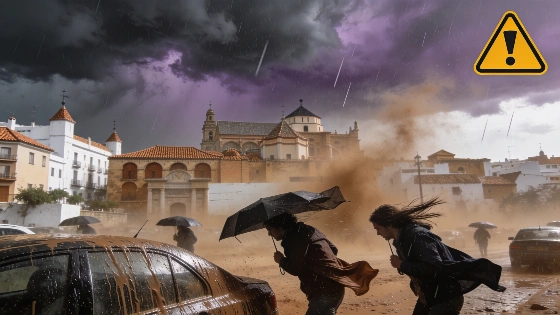
Eastern Spain faces another weekend of unsettled weather as storms, strong winds and Saharan dust converge, creating hazardous conditions and muddy rainfall across several regions. The calima, a mass of suspended dust from North Africa, is intensifying and spreading, leading to yellow wind alerts and dirty skies from Valencia to Andalusia.
After a week marked by afternoon storms and sudden gusts, the situation remains volatile. While the intensity of storms is expected to decrease compared to previous days, authorities have not lifted weather warnings. On Friday, thunderstorms are likely to develop over the Pyrenees and the southeastern interior, particularly affecting the Comunidad Valenciana, Murcia, Albacete and eastern Andalusia. The Spanish meteorological agency has issued yellow alerts for strong wind gusts in Valencia, Albacete and Murcia, where storm activity could be accompanied by hail.
Rainfall will also persist in Galicia and the Cantabrian coast, though these showers are forecast to be light and diminish by the afternoon. Throughout the weekend, the Cantabrian regions will continue to see weak precipitation, while storm cells are expected to form again in the afternoons, mainly in the same eastern and southeastern areas.
Saturday brings a renewed risk of stormy downpours in the Pyrenees, Teruel, the interior of Castellón, Valencia, Alicante, Albacete and inland Murcia. Yellow warnings for wind and hail remain in effect for Valencia, Albacete and Murcia. By Sunday, the forecast indicates a similar pattern, with new storm clusters likely to develop in the interior of the Comunidad Valenciana, Murcia, southeastern Castilla-La Mancha and eastern Andalusia.
The calima is set to worsen, with dust-laden skies expected to persist over Mediterranean regions. Over the weekend, the haze will be visible in Catalonia, Comunidad Valenciana, Murcia, eastern Castilla-La Mancha, much of Andalusia, Ceuta, Melilla and the Balearic Islands. As a result, rainfall in these areas will often be mixed with dust, producing muddy or so-called "blood rains"—a phenomenon that has already been observed in parts of the eastern peninsula.
Looking ahead to next week, the advance of warm air masses is likely to extend the calima further. By Monday, dust could reach all of Andalusia, Castilla-La Mancha, southern Extremadura and possibly Madrid, while remaining entrenched along the Mediterranean coast. This pattern of suspended dust and sporadic muddy rainfall is expected to continue, affecting air quality and visibility in affected regions.
Spain's recent weather instability echoes other natural events in the region, such as the wildfire crisis that forced evacuations in Zaragoza and threatened the Sierra Norte Natural Park. For more on how extreme weather has impacted Spanish communities, see the report on the Orés wildfire and its consequences for local residents: devastating wildfires in Zaragoza.
Calima events are not uncommon in Spain, especially during spring and early summer, when southerly winds transport Saharan dust across the Mediterranean. These episodes can reduce air quality, impact respiratory health, and create challenging driving conditions due to reduced visibility and muddy precipitation. Residents in affected areas are advised to monitor local weather updates and heed official warnings, particularly regarding outdoor activities and travel during periods of intense dust and storm activity.