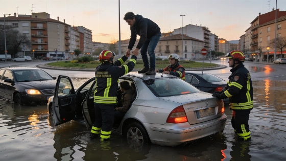
Emergency crews have rescued 24 people from vehicles across Tarragona. Xerta suffered the worst flooding as alerts spread toward Barcelona and Girona.
Eighteen people needed help in Xerta after floodwater covered roads across Tarragona. Emergency crews rescued 24 people from vehicles in the region. Two further rescues took place in Vandellòs, with two more in Cambrils. Roads became dangerous fast.
The storm is moving toward Catalonia's coastline and prelitoral areas. Interior chief Núria Parlon has told residents to avoid rieras streams and flood-prone zones. She also urged people to postpone or bring forward non-essential travel until the danger eases.
The only relevant indexed result identified in the available search was a Generalitat de Catalunya agenda page concerning an event in Terres de l’Ebre, rather than a dedicated weather or emergency bulletin.
Protection Civil issued an ES-Alert at 17.45 for residents of Baix Camp Baix Ebre Ribera d'Ebre and Terra Alta. A second mass warning followed shortly after 19.00. It covered Barcelonès Baix Llobregat Garraf Gironès Maresme and La Selva.
Residents in those areas were told to limit movement. Torrential rain could continue until two in the morning.
Granollers in Barcelona province also received a warning. Monday's downpours hit the municipality hardest. A specific ES-Alert for Granollers forecasts more torrential rain until 2.00.
The Generalitat de Catalunya page found in the available search does not contain rainfall measurements, rescue figures, ES-Alert notices or road-closure information. It therefore adds no independently verified operational detail to the account of the storm response.
Meteocat forecaster Santi Segalà says the storm has an unusually tropical character. The system is producing very intense rain in exceptionally short periods.
The measurements show how quickly conditions changed. Vinyols i els Arcs received 46 litres per square metre in half an hour. Riudecanyes recorded 43, while Mont-roig del Camp recorded 40.
Several locations received between 60 and 80 litres in three hours. The unstable weather is expected to move out over the sea from midnight. Rainfall should ease before dawn.
The roads took part of the hit. The A-7 and C-43 reopened after landslides and flooding caused closures. The C-12 remained completely covered by water in southern Catalonia.
That changed quickly.
Sudden accumulations and blocked carriageways explain the authorities' focus on mobility. Residents are being told to limit movement rather than simply watch the forecast.
The episode follows several days of severe weather in the region. The scale of the disruption was also reported earlier. Drivers can become trapped before officials formally close a route.
Wednesday should bring a short break from the heaviest rain. Weaker showers will remain. Temperatures are expected to fall across the region as tramontana and mestral winds arrive.
Relief may be brief.
Flooded roads and waterways will still pose a risk while the alerts remain active. The advice is simple: avoid unnecessary travel.
Rescues took place in four Tarragona municipalities. Roads remain closed, and warnings cover 12 comarcas. The main danger is rapid water accumulation in places where vehicles cannot escape.
Until the storm moves offshore, authorities are telling people to limit unnecessary mobility. That warning should guide travel decisions.